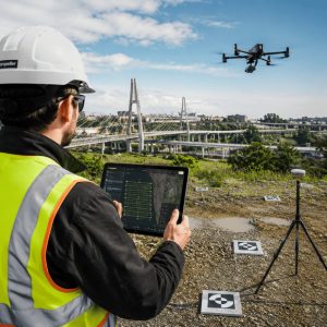
Infrastructure systems worldwide face unprecedented pressure. Aging bridges, expanding road networks, deteriorating power grids, and sprawling pipeline systems require constant monitoring to ensure safety, efficiency, and regulatory compliance. Traditional inspection methods like manual surveys, ground-based assessments, and manned aircraft are costly, time-consuming, and often dangerous.
The infrastructure deficit is staggering. According to recent estimates, the United States alone needs over $2.6 trillion in infrastructure investment over the next decade. Europe faces similar challenges with aging transportation networks and energy systems. Meanwhile, developing nations are building new infrastructure at breakneck speed, requiring efficient monitoring from day one.
Enter drone mapping technology, a transformative approach that combines unmanned aerial vehicles (UAVs) with advanced sensors and software to capture, process, and analyze infrastructure data with unprecedented speed, accuracy, and cost-effectiveness. In this article, TwinSphere explores how aerial mapping technology is revolutionizing infrastructure management for government agencies, engineering firms, and utility companies.
What Is Drone Mapping and How Does It Work?
Drone mapping is the process of using unmanned aerial vehicles equipped with specialized cameras and sensors to capture aerial imagery and data, which is then processed into accurate 2D maps, 3D models, and actionable intelligence. Unlike traditional aerial photography, drone mapping creates georeferenced, measurable datasets that integrate seamlessly with engineering and GIS workflows.
Core Technologies Behind Drone Mapping
Photogrammetry
Photogrammetry is the science of making measurements from photographs. In drone surveying, UAVs capture hundreds or thousands of overlapping images from multiple angles. Specialized software identifies common points across images and uses triangulation to calculate the three-dimensional position of every feature.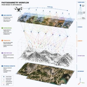
The process generates:
- Point clouds containing millions of georeferenced data points
- Digital Surface Models (DSM) showing terrain and object elevations
- Digital Terrain Models (DTM) representing bare-earth topography
LiDAR Scanning
Light Detection and Ranging (LiDAR) uses laser pulses to measure distances with extreme precision. Drone-mounted LiDAR systems emit up to one million laser pulses per second, creating dense point clouds that penetrate vegetation and capture fine structural details invisible to cameras.LiDAR excels in:
- Corridor mapping for railways, highways, and pipelines
- Powerline inspection with precise clearance measurements
- Forest and vegetation management around infrastructure
- Structural deformation detection on bridges and dams
Orthomosaic Maps
An orthomosaic is a geometrically corrected aerial image where every pixel represents true ground position and scale. Unlike perspective photographs, orthomosaics eliminate distortion caused by camera angle, terrain relief, and lens characteristics.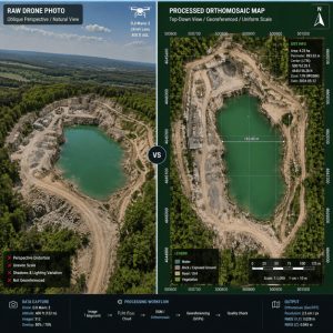
These maps serve as:
- Base layers for GIS and CAD systems
- Visual documentation for project stakeholders
- Change detection baselines for monitoring infrastructure evolution
- Measurement tools for distance, area, and feature extraction
3D Modeling
Drone-captured data transforms into detailed three-dimensional models that engineers can measure, analyze, and share. These models include:- Mesh models with photorealistic textures for visualization
- CAD-compatible models for engineering design integration
- BIM (Building Information Modeling) integration for facility management
- Virtual reality environments for stakeholder presentations
Benefits of Drone Mapping for Critical Infrastructure
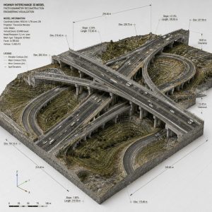
Bridges
Bridge inspection traditionally requires lane closures, scaffolding, or specialized vehicles—expensive and disruptive approaches. Aerial infrastructure inspection using drones provides:- Complete structural documentation, including hard-to-reach areas like pier caps and bridge undersides
- Crack detection and measurement with millimeter precision
- Thermal imaging to identify delamination, moisture intrusion, and structural defects
- Historical comparison to track deterioration rates and prioritize maintenance
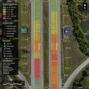
Roads and Highways
Transportation agencies manage thousands of miles of roadway requiring regular condition assessment. Drone mapping delivers:- Pavement condition surveys identifying cracks, potholes, rutting, and surface distress
- Asset inventory cataloging signs, markings, guardrails, and drainage structures
- Traffic pattern analysis, when combined with video analytics
- Construction progress monitoring with volumetric measurements for earthwork and materials
Railways
Rail networks demand precise geometric measurements and continuous monitoring for safety. Drone surveying provides:- Track geometry analysis measuring alignment, gauge, and cant
- Clearance verification ensuring adequate space for rolling stock
- Vegetation management identifies encroachment risks
- Embankment stability monitoring, detecting erosion and subsidence
Power Lines and Transmission Infrastructure
Energy utilities manage vast transmission networks across challenging terrain. Drone mapping enables:- Conductor sag measurement ensuring proper clearances
- Insulator and hardware inspection, identifying damage and contamination
- Vegetation encroachment analysis with precise distance measurements
- Thermal anomaly detection reveals hotspots indicating electrical faults
Oil and Gas Pipelines
Pipeline operators face regulatory requirements for regular inspection across remote and difficult terrain. Drones provide:- Right-of-way monitoring, detecting encroachment and unauthorized activity
- Leak detection using thermal and gas-sensing cameras
- Erosion and subsidence monitoring, identifying threats to pipeline integrity
- Construction and maintenance documentation for regulatory compliance

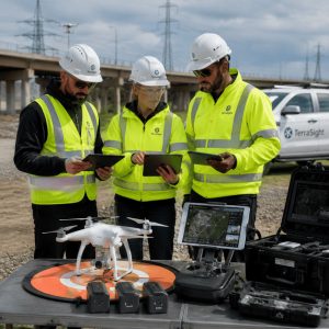
The Complete Drone Mapping Workflow
Understanding the end-to-end process helps organizations implement aerial mapping technology effectively.1. Planning and Preparation
Success begins with proper planning:- Define objectives: Determine required accuracy, deliverables, and data formats
- Site assessment: Identify airspace restrictions, obstacles, and safety considerations
- Regulatory compliance: Obtain necessary permits and authorizations
- Flight planning: Design flight paths ensuring adequate overlap and coverage
2. Data Acquisition
Field operations involve:- Pre-flight checks: Verify equipment, weather conditions, and safety protocols
- Ground control points (GCP): Place surveyed markers for georeferencing accuracy
- Autonomous flight execution: Drones follow pre-programmed paths capturing imagery
- Quality assurance: Verify data completeness and quality before leaving the site
3. Data Processing
Raw imagery transforms into actionable intelligence through:- Image alignment: Software identifies matching features across overlapping images
- Point cloud generation: Photogrammetric or LiDAR processing creates 3D point datasets
- Model creation: Point clouds become mesh models, orthomosaics, and elevation models
- Georeferencing: GCP integration ensures survey-grade accuracy
4. Analysis and Deliverables
Processed data supports various applications:- Measurement and quantification: Extract distances, areas, volumes, and elevations
- Change detection: Compare datasets from different dates to identify changes
- Asset condition assessment: Classify defects and prioritize maintenance
- Integration with enterprise systems: Export to GIS, CAD, and asset management platforms
5. Reporting and Decision-Making
Final deliverables include:- Interactive 3D models accessible via web browsers
- Annotated maps and drawings highlighting findings
- Quantitative reports with measurements and statistics
- Recommendations for maintenance, repair, or further investigation
Traditional Surveying vs Drone Mapping
| Aspect | Traditional Surveying | Drone Mapping |
|---|---|---|
| Data Collection Speed | 5-10 acres per day | 100-400 acres per day |
| Personnel Required | 2-4 surveyors | 1-2 operators |
| Safety Risk | High (traffic, terrain, heights) | Low (remote operation) |
| Accessibility | Limited by terrain and hazards | Excellent (aerial access) |
| Data Density | Sparse point measurements | Millions of data points |
| Cost per Acre | $500-2,000 | $50-200 |
| Traffic Disruption | Significant (lane closures) | Minimal to none |
| Repeat Surveys | Expensive and time-consuming | Fast and economical |
| Visual Documentation | Limited photographs | Complete imagery coverage |
| Deliverable Timeline | 2-4 weeks | 2-5 days |
Integrating Drone Mapping with AI and GIS Systems
The true power of aerial mapping technology emerges when integrated with artificial intelligence and geographic information systems.Artificial Intelligence and Machine Learning
AI transforms raw drone data into actionable intelligence:- Automated defect detection: Neural networks identify cracks, corrosion, spalling, and other infrastructure defects with over 95% accuracy
- Asset classification: AI catalogs infrastructure components (signs, lights, manholes) automatically
- Predictive maintenance: Machine learning models forecast deterioration and optimize maintenance schedules
- Change detection: Algorithms automatically identify differences between survey dates

GIS Integration
Geographic Information Systems provide the framework for infrastructure management:- Spatial analysis: Combine drone data with demographic, environmental, and operational datasets
- Asset management: Link visual data to maintenance records, specifications, and work orders
- Network analysis: Optimize routing, service areas, and resource allocation
- Public engagement: Share interactive maps with stakeholders and communities
Digital Twin Technology
Digital twins—virtual replicas of physical infrastructure—represent the convergence of drone mapping, IoT sensors, and real-time data:- Real-time monitoring: Sensor data overlays on accurate 3D models
- Scenario simulation: Test maintenance strategies and design changes virtually
- Lifecycle management: Track infrastructure from design through decommissioning
- Stakeholder collaboration: Provide a common operating picture for all parties
Practical Implementation Strategies for Organizations
Successfully deploying drone mapping requires strategic planning and organizational commitment.1. Start with a Pilot Project
Begin with a manageable project demonstrating value:- Select a high-priority asset or corridor
- Define clear success metrics (cost savings, time reduction, data quality)
- Document results and lessons learned
- Use success to build organizational support
2. Build Internal Capabilities vs Outsourcing
Organizations face a build-or-buy decision:- In-house programs offer:
- Greater control and flexibility
- Lower long-term costs for frequent surveys
- Institutional knowledge development
- Faster response to urgent needs
- Service providers offer:
- No capital investment
- Access to the latest technology
- Specialized expertise
- Scalability for large projects
3. Invest in Training and Certification
Successful programs require skilled personnel:- Pilot certification: Obtain required licenses (Part 107 in the US, equivalent elsewhere)
- Technical training: Learn data processing and analysis software
- Safety protocols: Develop standard operating procedures
- Regulatory compliance: Understand airspace rules and privacy requirements
4. Select Appropriate Technology
Match equipment to applications:- Entry-level systems ($2,000-10,000): Suitable for basic mapping and inspection
- Professional platforms ($10,000-50,000): Survey-grade accuracy, longer flight times
- Specialized sensors ($20,000-100,000+): LiDAR, thermal, multispectral for advanced applications
5. Establish Data Management Workflows
Drone programs generate massive datasets requiring:- Storage infrastructure: Cloud or local servers with adequate capacity
- Processing pipelines: Automated workflows from raw data to deliverables
- Quality control: Verification procedures ensuring accuracy and completeness
- Data governance: Policies for retention, security, and access
6. Integrate with Existing Systems
Maximize value by connecting drone data to:- Asset management systems: Link visual data to maintenance records
- GIS platforms: Create spatial infrastructure inventories
- Project management tools: Track construction progress and compliance
- Financial systems: Support capital planning and budget allocation
7. Address Regulatory and Privacy Considerations
Successful programs navigate:- Airspace authorization: Obtain necessary approvals for operations
- Privacy protection: Develop policies for data collection near sensitive areas
- Data security: Protect infrastructure information from unauthorized access
- Insurance coverage: Ensure adequate liability protection
8. Measure and Communicate Value
Demonstrate program success through:- Cost-benefit analysis: Document savings versus traditional methods
- Safety improvements: Track incident reduction and risk mitigation
- Efficiency gains: Measure time savings and productivity increases
- Decision quality: Show how better data improves outcomes
The Future of Infrastructure Management
Drone mapping and aerial mapping technology have evolved from experimental tools to essential infrastructure management capabilities. Organizations worldwide report dramatic improvements in safety, efficiency, and decision-making quality.The technology continues to advance rapidly. Artificial intelligence automates analysis, extended flight times enable larger coverage areas, improved sensors capture finer details, and cloud platforms democratize access to sophisticated processing capabilities.
For government agencies, engineering firms, and infrastructure operators, the question is no longer whether to adopt drone mapping, but how quickly to implement it. Early adopters gain competitive advantages through better data, faster response times, and more informed decision-making.
The infrastructure challenges facing society—aging systems, limited budgets, safety imperatives, and sustainability requirements—demand innovative solutions. Drone mapping provides the accurate, timely, and comprehensive data needed to meet these challenges head-on.
Organizations beginning their drone mapping journey should start small, learn quickly, and scale strategically. The investment pays dividends through decades of improved infrastructure management, ultimately serving the communities and economies that depend on safe, efficient, and resilient infrastructure systems.


